 REWT
Rivers of England and Wales, Temporally
Evidence
What each source can say, what it cannot, and whether it can be published.
The modern network
OS Open Rivers (Ordnance Survey, Open Government Licence) is the spine: a national watercourse network with names and topology. It is a cartographic product and does not claim to be hydrologically routable — which is the whole of the first phase’s work.
It says nothing whatever about premodern courses, and is treated as the least reliable evidence in the places where most has changed.
The map record
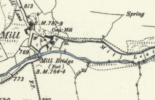
Victorian six-inch sheets (National Library of Scotland, georeferenced) are the base for tracing. The surveyors sometimes state which of two channels is superseded — Old Course, New Cut — and GB1900, a volunteer transcription of every label on those sheets, makes those statements findable. A label is an assertion by someone who was there, which is worth more than an inference from the modern line.
Pre-Ordnance-Survey mill mapping — county maps, estate maps and the Roy Military Survey of 1729–1836, gathered by Mills of Britain (Jonell, Jones, Lucas and Naylor, CC BY 4.0; its companion layer is derived from GB1900 and carries that dataset’s CC0 terms) — carries 17,120 records in England and Wales, 10,371 of them water-powered. It attests mills 60 to 170 years before the six-inch sheets, and 47% of its water-powered sites have nothing within 250 m in the mill layer filtered from those sheets, so as a record of mills it is genuinely additional. As a way of finding the labelled mill channels it is much weaker — under a third of them have one of its sites within 250 m, and the two are not the same population. It does not date anything either: its year field is the final survey or publication year of the map the mill was read from, a terminus ante quem from cartographic attestation with no documentary or archaeological date behind it. Earlier evidence that a mill stood is earlier evidence that a leat existed, and that is the whole of what it offers.
Domesday cannot be pressed into service either, and fails twice over. It is the source that could in principle date a mill rather than merely attest it earlier, so it is worth saying why it does not. The open transcription’s raw data carries a licence that is both non-commercial and share-alike, either of which alone would bar it from a project that must stay redistributable, and the folio images are share-alike too. But the objection survives the licence, which is the part worth keeping: Domesday counts mills per manor and does not place them. A manor is an estate of some square miles, so a record of two mills locates them to a parish at best and to a leat not at all. It is the mills-are-not-channels problem one step further back and an order of magnitude coarser. The usual answer to a licence objection is to go and ask for permission; here permission would buy nothing.
The archaeological registers were checked and cannot date a leat either. The National Heritage List for England is open, national and updated daily, but its published form carries no monument-type field at all — only a free-text name — so a watercourse has to be selected by string exactly as in GB1900, and the only structured date it holds is the date of listing, not of the asset. Names containing mill run into the thousands; those that say the mill was water-powered number a couple of hundred; those that mention a leat a few dozen — against some four thousand labelled mill channels. The list is rich in mills and nearly silent on channels, which is the distinction that defeats every other mill source on this page.
The Welsh equivalent has the structure and the wrong population, which is a more interesting result than the English one. The National Monuments Record of Wales publishes a controlled site type, a period, and — unusually — how the site is known, whether from an earthwork, a document, an excavation or a standing building: three structured fields the English list lacks entirely, and it records leats in their hundreds where England’s free text yields dozens. But read the records and the leats are named for collieries, lead mines and quarries. They are upland industrial water supply — channels feeding mines and ironworks — and not the valley-bottom mill channels this project reconstructs. A different population that shares a word. A structured field is not the same as the right content, and the lesson generalises: the temptation with a well-modelled dataset is to trust the schema and skip reading the rows.
One failure runs through all four of them. The pre-Ordnance-Survey mill mapping, the six-inch labels, the two national heritage registers and Domesday were compiled centuries apart, are structured differently, and are licensed differently — and they fail in the same way. Each records mills. This project needs channels. A mill is a point: well attested, often named, sometimes dated. The leat that fed it is a line, seldom named, drawn on a map as a watercourse like any other, and not dated by anything the record of the mill contains. That is no defect in any of them; it is what they were made for. But it means the mill channels will not be dated by finding a better mill source, and anyone tempted to look for one should know that four have been tried.
It does not, in the end, check the register. The hope was that an archaeologically recorded locator for Welsh impoundments — owing nothing to the undertaker’s declaration on a registration form — could test those declared dates. It cannot. The two sources barely overlap, most registered reservoirs having no monument record anywhere near them; and where they do meet, the monument record’s period is a category spanning centuries and cannot contradict a year. A test that cannot distinguish a disagreement from a coarse category is not a test, and the declared years remain untested.
What it holds instead is a slice of the population every other source excludes. A majority of its reservoir and dam records have no counterpart in the statutory register or the hydrological inventory — impoundments below the statutory threshold, or disused, abandoned, or known only archaeologically. Each carries a period, a note of how the site is known, and a permanent link to its entry.
It is a real addition and a modest one, and the qualifier matters more than the count. Barely a fifth of those records sit on standing water in the modern network at all: most are drained, silted, or too small to have been mapped as water, so they are records of where an impoundment was rather than of a lake to route around. About half sit on a modern watercourse, roughly a quarter carry industrial names — collieries, quarries, ironworks, the same population problem as the leats in a milder form — and only a handful carry a period earlier than the nineteenth century.
And how many of them are additional depends on a choice nobody can make principledly. Whether a monument record and a register entry describe the same reservoir is decided by how far apart they are allowed to be, and for a large reservoir the two sources point at different things — the archaeological record marks the dam, the register the body of water. Move the radius across the range a reasonable person would accept and the answer moves by more than half. That sensitivity is the honest finding, and a single number here would be a claim that the choice did not matter.
One structural limit applies throughout: a linear site is recorded as a point, at a grid reference taken somewhere along it, so nothing in this source can be traced from.
And its own terms contradict themselves. Traced past the hosting platform to the body that made the data, the statement says its digital site data may be used under the Open Government Licence v2.0, “which allows the commercial reuse of the data” — and, in the same passage, that to use information derived from it “to compile resources for commercial or organisational use, prior permission must be obtained in writing”. Those cannot both govern the same records. The passage repeats the permission requirement a second time, scoped explicitly to the archive records — the photographs, drawings and manuscripts, which are under the Non-Commercial Government Licence 1.0 and are not open at all — and that is the only reading under which the whole is coherent.
This project takes that reading: the Open Government Licence governs the site data, and the written-permission requirement governs the archive. Three things support it — the permission clause is stated a second time in the same passage with the archive named explicitly; both operative licences are real and correctly versioned; and the open statement is the one attached to the download route. The ambiguity is in the publisher’s text, not in this project’s position: the reading is settled here and recorded as a reading, so that anyone who goes to the source and finds the contradiction knows it was seen rather than missed. Anything derived from the site data must acknowledge it as “Derived from information compiled by RCAHMW and/or Crown copyright.” The exposure either way is small: the site data is described on this page and rejected on its content, so nothing downstream rests on it.
Two practical points follow. The archive and the site data sit behind one search interface, so a link followed from a site record lands among material under the restrictive terms. And this is the fifth time on this page that a licence has had to be traced past whoever was re-publishing it — but the first where the owner’s own statement is the one that disagrees with itself, which is a different problem from a re-publisher being careless.
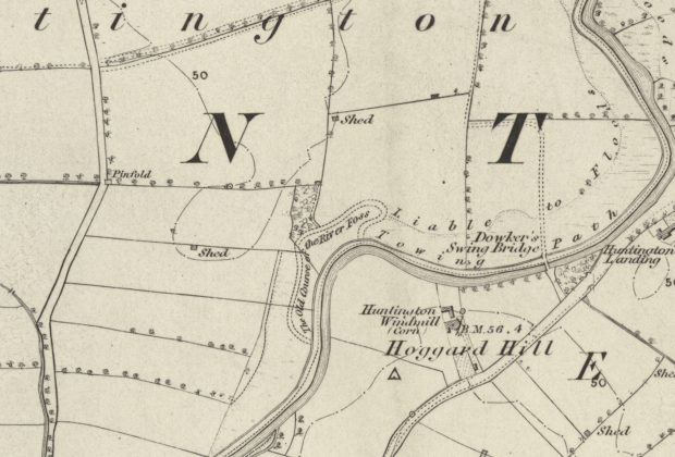
The first series matters where the second is too late: much of Victorian water supply predates 1888, so for a valley drowned in the 1870s the second series shows the lake and not the river. It is county-by-county rather than a single national mosaic, which is why it is more work — and it is georeferenced less consistently, which is why a trace has to record which sheet each vertex came from.
What the labels actually offer, measured against the transcription of 2.6 million of them, in England and Wales:
| label | labels | distinct places | what it is |
|---|---|---|---|
| Old Course | 139 | 126 | the surveyor stating which of two channels is superseded |
| New Cut | 224 | 209 | the same statement from the other side |
| Mill channels — Mill Race, Mill Leat, Mill Pond | 4,996 | 4,068 | frequently medieval, and belonging in the reconstruction rather than subtracted from it |
| Towing path | 2,169 | 1,724 | the channel carrying traffic c.1900 — ambiguous alone, disambiguated by the two above |
A label is not a channel. The Ordnance Survey repeated a name along the feature it named, so the second column collapses labels reading the same thing within a kilometre of each other into one place. The correction is smaller than it sounds — repeated captions are set 1.7 km apart on average, and no two Old Course labels lie within 300 m — but the counts are counts of places, and are labelled as such.
Two figures need saying plainly. The labels come from the CC0 raw dump, never from the published gazetteers, which are CC-BY-SA and would carry share-alike into this project’s exports. And the extent measured is England and Wales by country polygon: 1,888 of the 6,884 mill-channel labels in Great Britain fall in Scotland, lade and lead being Scots. That is a proxy rather than the project’s rule — scope is decided on basins, and a basin with any part in England or Wales is in scope entire, Scottish headwaters and all, so the counts undercount by whatever sits in the Scottish parts of the Tweed and the Border Esk. The scale page gives the method.
Some 274 outright assertions where Old Course and New Cut are taken together and counted by place, which is a small enough number to work through completely, against some 4,068 judgements, which is not. That difference drives the release plan, and the scale page sets out what follows from it.
And the labels are a lower bound on the sheets. A surveyor captioned a superseded channel where the fact seemed worth recording, which is nowhere near everywhere a river has moved — so the transcription finds the assertions and misses the silent majority. The sheets themselves record the course everywhere they cover, and reading them systematically along each river, rather than only where a label points, is a different and much larger body of evidence from the same paper. The methodology sets out how that sweep is meant to work and why its threshold has to be set above OS Open Rivers’ own generalisation.
A second population is not labelled at all: channels drowned by reservoirs. A drowned
valley is not a channel that ceased to exist — it is one that is under water, and its course
is recoverable from a map made before the dam. The network cannot find them by name, which is not the same as
their being absent from it. Of 24,146 standing-water links, 18,104 are unnamed; of the rest,
about 68% carry a running-water name and fewer than 5% a standing-water one, and none at all
contains the word Reservoir. That is guaranteed by the specification rather than
discovered in the data: OS Open Rivers has no water-body feature type at all. It has two
features, a watercourse link and a node; lake is a form that a stretch of watercourse
takes — “a large area of non-tidal water without an obvious flow that is enclosed by land” —
and the name field names the watercourse. A reservoir has nowhere in the schema to be named.
So the reservoirs are in the network, under the names of the valleys they drowned: Kielder
Water’s links are still Belling Burn and Cranecleugh Burn. A gazetteer of named places is needed, and has to be declared before any count from it
can be quoted; the scoping exercise’s 606 reservoirs over 1,834 links was obtained that way
and is inherited here, not earned.
Their dates can be looked up, for the large ones. The CEH inventory of UK reservoirs (Open Government Licence) holds 273, of which 233 are in England and Wales and 252 carry a completion year. Its threshold is stated — over 1,600 Ml, plus smaller ones in a group with historic storage information — so the big reservoirs are dated and the small Victorian impoundments are simply absent. Wikidata is not a substitute and was tested: 24 of 1,125 items typed as UK reservoirs carry a construction date, and Kielder, Rutland, Ladybower, Haweswater, Vyrnwy and Derwent are all among those that do not.
The statutory registers are the better instrument, and only one country publishes one. Every reservoir holding water above the level of the surrounding ground is registered under the Reservoirs Act — over 25,000 m³ in England, over 10,000 m³ in Wales — which is a raised water test, far closer to “this drowned a valley” than a storage threshold is, and which reaches well below the hydrological inventory. Natural Resources Wales publishes the Welsh register as open data under the Open Government Licence — 400 reservoirs, 316 impounding, 365 with a year built, and 366 of them smaller than the hydrological inventory’s threshold, which is to say it holds the tail that the inventory is built to exclude. The Environment Agency does not publish the English one: it must be requested by letter, email or telephone. Treat a registered year as what it is — a declaration made by the undertaker on a regulatory form, with no source recorded — and not as the same kind of evidence as the inventory’s flagged and referenced dates.
What the date buys is the edition. Compared against the County Series survey dates for the county, a completion year says which map shows the valley before it was flooded — and two in five of the impounding reservoirs in England and Wales need the first edition or earlier, with nineteen predating both. The scale page gives the breakdown. Where no date exists the map comparison still answers it, a valley drawn as a river on the first edition and as water on the second having been flooded between the two surveys; the inventory only means the tracer knows which sheet to send for.
Beware the same trap as GB1900 here. Wikipedia’s list of UK reservoirs is the identical content — the same 273 rows, sourced from the same inventory — under CC-BY-SA. The share-alike version of an open dataset is not a convenience; it is a licence this project cannot take. Use the original.
Distinguishing a reservoir from a merely wide river is otherwise tractable: measured channel width is a good second signal (trunk channels run to a median 34.9 m, so anything an order of magnitude wider is not a widening), and a reservoir is a polygon the network has to be routed across rather than along.
A third, larger population — 19,434 courses fossilised in parish boundaries — is identifiable but rests on a licence-encumbered boundary set, and so cannot be published from. It is noted here because its absence is a real limit, not an oversight.
Maps that show the valley before the dam
The six-inch is the base case and its limit is now measured rather than assumed: two in five of the impounding reservoirs in England and Wales need the first edition or earlier, and in Wales, where the county first editions were surveyed late — mostly 1873–1888 — a large minority of reservoirs predate both editions. So the question “what shows the valley before the dam” has to be answered below the six-inch, and this is what is on the shelf.
| source | what it shows | state |
|---|---|---|
| OS six-inch County Series, 1st edition | the channel itself, 1:10,560 | georeferenced, national — the default, and the last survey before the dam almost everywhere |
| OS County Series 25-inch, 1:2,500 | the channel’s two banks, and its width | 165 county tilesets; a few per cent less complete than the six-inch, and a different question |
| the same series, 2nd edition | the channel where the dam came later still | often the lake instead; check the sheet’s survey date, not the edition |
| OS one-inch Old Series, 1801–1869 | the valley; rarely the channel, at 1:63,360 | georeferenced, 746 sheets — earlier than the six-inch over much of the country, and untested for this purpose |
| Pre-Ordnance-Survey county maps, c.1729–1836 | valley and settlement at county-map scale | scattered across a dozen libraries; georeferencing is the tracer’s problem |
| Tithe maps, 1836–1852 | the best large-scale coverage before the six-inch | Wales: 1,224 maps, over 95% of the country, georeferenced by volunteers. England: no national equivalent |
| Enclosure maps and awards | large scale, patchy by construction | county record offices; unassessed |
| Deposited plans for the waterworks Acts | the works and the ground taken — the channel, not only the valley | indexed nationally and item by item; nothing digitised |
The 25-inch is not a better six-inch
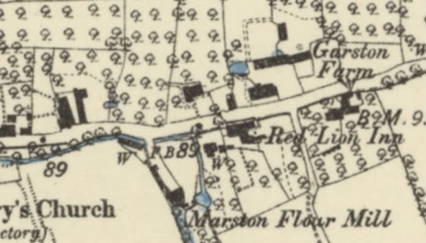
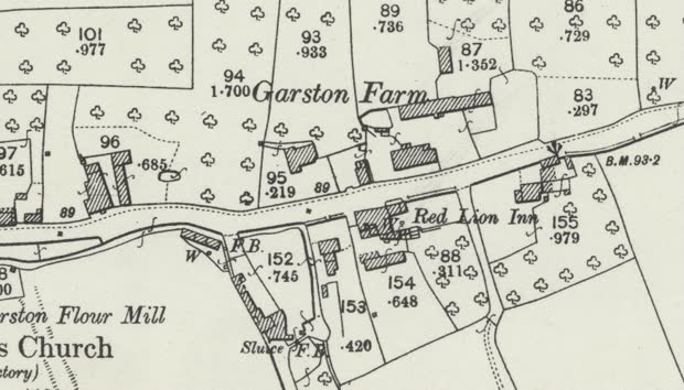
The County Series 25-inch, at 1:2,500, resolves an order of magnitude finer than the six-inch and is not simply a better version of it. Ordnance Survey draws a watercourse as a single line below a certain ground width and as two banks above it — so a finer sheet double-banks far more channels, and a mill leat that is one stroke at six-inch becomes a pair of lines with the water between them at 25-inch.
That changes the question the sheet answers. The 25-inch says how wide the channel was and where its edges ran; the six-inch says where it ran. For tracing a course the coarser drawing is often the more directly useful one, because a single stroke is a line to follow and two banks are two lines with the answer in between — an ink-following tool locks to one bank and sits half a channel-width out.
And the colour cannot be predicted from the scale. Where water is washed blue it can be segmented by hue, which sidesteps the problem entirely — but whether a sheet is coloured varies sheet by sheet and it varies in both directions. At Northwich the 25-inch carries the wash and the six-inch does not; at Marston, above, it is exactly the other way round. A tool must test the sheet in front of it rather than infer from the series or the scale.
Which makes the two sheets complementary in a way that is worth building on. A line traced from the six-inch is a course; the 25-inch holds the width of the same channel and cannot easily be traced, because there is no single line on it to follow. But a course is the instrument for reading a width: given a well-placed centreline, a machine can step along it, cut across the channel at right angles at intervals, and measure the distance between the two banks — or across the tint, where the sheet is coloured. One traced line then yields two measurements, the second of them obtained without anybody tracing the finer sheet at all, and channel width is a quantity this project has no other open historical source for.
Four conditions on that, and the first is the one that bites. The measurement inherits the trace’s error: a centreline half a channel out returns a width that is wrong and looks entirely reasonable, so this is a use for carefully placed traces and not for rough ones. It works only where the 25-inch covers the reach, only where the channel is wide enough to be drawn as two banks at that scale — a narrow leat is a single stroke there too — and the sheet has to be classified first, since whether the water is tinted varies between sheets in both directions. And what it measures is the channel as drawn at that survey, which is a historical width and not a present one; that is the point of wanting it.
Two practical notes. Coverage is a few points short of the six-inch — sampled against network midpoints inside three historic counties, 88–96% against the six-inch’s 94–100% — and the reason is not known: the obvious hypothesis, that the gaps are uncultivated moorland where the 25-inch was not published, was tested and did not hold. And there is no series date: counties carry their editions as separate tilesets — Gloucestershire has four — so a date belongs to a sheet and never to the series.
Its licence position is the six-inch’s exactly, and was checked rather than assumed: same bucket, and absent from the same per-layer re-use table.
Reach for the first edition, and check the sheet rather than the edition
The rule is not “the first edition usually helps”. Checked sheet by sheet against the survey dates for fourteen of the largest reservoirs in England and Wales, the first edition is the last survey taken before the dam in every one — Kielder surveyed 1862 against a dam of 1975–82, Haweswater 1858–59 against 1929–35, Rutland Water 1884 against 1970–75, Llyn Celyn 1886 against 1965. The only case where survey and construction overlap at all is Lake Vyrnwy, surveyed 1885 against a dam of 1881–88 — and even there the sheet carries the valley.
Vyrnwy is worth looking at because it shows exactly what one edition holds and the next does not. On the 1885 sheet the floor of the valley carries the village of Llanwddyn entire: St John the Baptist’s church and vicarage, the Powis Arms, two Methodist chapels, a school, a post office, two more public houses, a disused corn mill, and the bridges Pont Cedig and Pont Dol-wenith over the Afon Efyrnwy — which is drawn as a river the whole way through. At the edge of the same sheet, already labelled, are the reservoir works that would drown all of it. The surveyor mapped the village and the thing that would destroy it on one sheet. At the identical extent in 1900 there is open water, the lettering of the lake’s name, a rain gauge and a new house on the shore. The church, the chapels, the mill, the bridges and the river are simply not there.
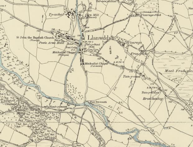
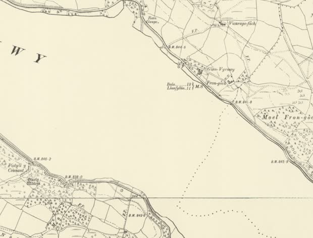
But the edition number is not the rule; the survey date is. At the Elan Valley the second edition, surveyed 1902–04 while the dams were going up, draws both at once — the reservoirs annotated in course of construction, and the Afon Elan still running as a continuous channel through ground that was about to go under. So the honest statement is: the last survey taken before the reservoir filled carries the channel, and carries it whether or not the works are already on the sheet. Once the water is in, Ordnance Survey records the lake and stops; the drowned channel is neither drawn nor annotated. For England and Wales that last-before-filling survey is the first edition nearly everywhere, which is why it is the default — but the sheet’s own date is what settles it.
And one thing survives the water. On the 1900 Vyrnwy sheet a single dotted line crosses the lake: a parish boundary, which is a legal object and does not drown. Where a boundary followed a river, it is a witness to the channel after the channel is gone. That is a general possibility rather than a demonstrated one — this particular boundary runs near the Efyrnwy rather than along it, and one place is not a sample — but it is the only linear feature on that sheet that outlived the flooding, and it is the same argument the boundary-fossil candidates rest on.
The deposited plans are the best-evidenced route on that list, and water schemes are what the series was created for. From 1793, Standing Orders required an application for a local Act to be accompanied by a detailed plan deposited with the Clerk of the Peace of every county affected — and the requirement covered canals and waterworks, railways only being added in 1803. Each plan came with a book of reference naming the owner and occupier of every parcel of land the scheme would take. That is the argument this page already makes about navigation legislation, in its strongest form: a compulsory purchase is a legal act over specific ground, drawn at large scale by someone who had to be accurate about it. It is the only source here that would show a channel rather than a valley.
The index exists, it is national, and it is one catalogue. The obvious fear — that finding a plan means working through county record offices one at a time — is wrong. The National Archives’ Discovery catalogue aggregates the county record offices alongside its own holdings, so a single search reaches Bolton, Derbyshire, Leicestershire and Kew together. The parliamentary series is catalogued item by item: the House of Lords deposited plans of 1794–1841, formerly listed only by box, were re-catalogued in December 2022 to give every plan its own reference on the scheme already used for 1842 onwards.
Searched against the fifteen reservoirs with no Ordnance Survey edition behind them, eleven return a catalogued record naming the place — the deposited plan and reference book for the 1843 Belmont Reservoir extension is at Bolton, and Belmont Reservoirs of the same session is at Kew. Two of the four misses close when the search is the undertaking instead of the reservoir: Tittesworth returns nothing under its own name and the Staffordshire Potteries Waterworks deposits of 1847 and 1849 are there under the company’s. That is the practical lesson — a nineteenth-century plan is titled for the company and the Act, because the reservoir frequently had no name yet.
Four things temper it. A catalogue hit is a mention, not a confirmed plan for that
scheme. Catalogue depth is very uneven, and a good many entries are titled no more than
“Plan” or “Book of reference”, so the index makes a holding findable without saying what is
on the sheet. Nothing is digitised: establishing that a plan exists is an hour at a
keyboard, and reading one is a visit to a record office, per reservoir. And access is in
flux — the Parliamentary Archives has closed and its collections are moving to The National
Archives, which is why these references now carry a Y prefix, so the reference form should
not be assumed stable.
Two of the strands meet on the same shelf. The pre-Ordnance-Survey county maps are the only cartographic evidence for the Welsh reservoirs that predate both OS editions, and they are the same corpus the mill mapping was compiled from. A project that digitises or georeferences that material serves the drowned valleys and the mill channels at once, which is worth knowing before either is costed separately.
Take the method, not the data
Twice now the same answer has come out of a licence problem, and it is worth naming because it will come up again. A source that cannot be republished may still be followed: its citations lead to material that can be retraced independently, and its method is not its data.
- A dated navigation corpus that cannot be redistributed names, section by section, where each course came from. Follow the citation, get the map or the book, and trace it here at six-inch resolution. The finding travels; the geometry does not.
- A sea-routing graph inherits the terms of the coastline it is built over — a derived
database of share-alike data is share-alike whatever anyone intends. But the routing method
carries nothing, and coastlines are interchangeable: several open ones exist, and
Boundary-Line’s
high_wateris Open Government Licence and already in hand.
An author’s willingness is not the binding constraint when an input already imposed one, which is the same lesson as the share-alike gazetteers and the safeguarded deposit, arriving from a third direction. The corollary is the useful part: ask what a dataset is made of before asking who owns it. Sometimes the answer is that the constraint does not bind at all — a component can be swapped for an open equivalent, or the encumbered layer covers ground this project never enters.
The licences here are per image, not per site. The National Library of Scotland offers much of its map imagery under CC-BY with the acknowledgement “Reproduced with the permission of the National Library of Scotland”, but is explicit that terms vary by collection, with some under CC-BY-NC-SA and third-party content carved out entirely. That is the same lesson as the GB1900 gazetteers and the mill layers: an item’s licence is not its collection’s licence, and this project checks the item.
For the georeferenced sheets, the trace fails and the terms here rest on a decision. The
copyright page covers map images and is silent on the tile services that a web map actually
consumes. Checked: the per-layer re-use table in the georeferencing guide does not list the
England and Wales layers; the tilesets’ own metadata carries an attribution naming the
rendering software and no rights statement; the WMTS and WFS capabilities documents contain no
licence, access-constraint or fee element at all; and there is no licence file in the bucket.
So the sheets above are used as CC-BY by this project’s own ruling, not by a statement from
the Library — recorded that way deliberately, on a page arguing that licences must be traced
rather than assumed. That ruling covers rights. It does not cover the Library’s separate
request that these layers be used locally rather than served from a public site, which is a
request about their infrastructure and is a different question with a different answer.
A trap worth naming, because it is the shape this page keeps meeting. The tilesets’ metadata does carry a populated
attributionfield — and it credits the rendering software. A populated field is not a rights statement: a well-formed value, in the right-looking place, answering a different question.
What has been looked for and not yet found
Named so that nobody repeats the search, and so that anyone who can close one of these knows it is wanted:
- An open source enumerating the English large raised reservoirs with locations. The statutory register is not published; the flood-extent dataset implies the list without naming it.
- Licence and bulk access for the Welsh tithe maps, which are digitised and georeferenced but whose reuse terms are not established here.
- Whether the one-inch Old Series shows enough, at 1:63,360, to be worth a tracer’s time. Testable on a single reservoir.
- Whether a catalogued deposited plan is the plan for the scheme — the index finds records naming a place; only the document says what it draws.
- An openly redistributable dated navigability layer. The best one that exists is safeguarded, so the project can consult it and cannot publish from it; the towing-path labels are open but undated. Nothing yet fills the gap between them.
And one deliberately deferred. The Victoria County History will often date a mill or a
reservoir where the maps only locate one, and it is noted here as a fallback rather than
investigated. Two reasons, and the second is the one that generalises. Its coverage is
England only and partial, so it cannot answer at national scale. And being able to read a
source is not the same as being able to republish it: a text can support a curated
judgement — a reason in words with an evidence string naming a volume and a page — while
its own words may not travel into an export. Nothing on this page yet occupies that category,
the terms have not been established for the VCH, and describing it as available would imply
an answer to a question nobody has asked yet.
The documentary record
Drainage and navigation legislation records works authorised, undertakers, and land taken — but authorisation is not execution, and several such powers were never exercised. Nothing here may be read as the river was navigable from this year; what it gives is a dated statement that somebody intended to make it so, and where. Two compilations covering 1539–1720 are open (CC BY) and already declared to this project — the compulsory purchase of land for transport infrastructure and the seventeenth-century patents for river improvement — each recording the Act or patent, the undertakers, the tenure taken and a citation per row.
That is the half of the navigation record that is dated at its start, which is exactly what the attested corpora are not: Oksanen’s records carry no start date and Satchell’s window is censored at 1600. A grant of powers in 1662 is a firm bound on when work could have begun, and a firm bound is what the date model is built to carry.
Their under-used value is different: a compulsory purchase is a legal act over specific ground, and a new cut had to be located relative to the channel it replaced — so the plans and awards behind it can show the river before the work. How reliably is an open question: survival is uneven, and many plans depict only what was proposed. Worth testing on a sample before it is relied on.
Regional studies — the Fenland Survey, the Humber Wetlands Project, the Somerset Levels literature — answer locally what no national rule can: which channels are older than they look, and which are engineering. National pattern rules that date a channel by its name — drain, cut, sewer — answer it crudely and should say so: in the Somerset Levels and Romney Marsh a sewer is a drainage channel and many have medieval origins even where the present cut is later.
A tenth of England lies inside an Internal Drainage District — 12,779 km, 13.3% of the mapped network — and that is the measurable extent of ground where the hydrography was rebuilt rather than modified. The rebuilt landscapes divides it into the regions that have to be worked out one at a time, with the schemes that reshaped each, when they were carried out, and the sources that record what was there before.
Navigation
This is a strand, not an attribute. The project’s name is a pun on route, and that is not decoration: a great deal of what the modern network looks like was done to make water carry things. River improvement in the late seventeenth century was driven above all by the need to get coal to towns where hauling it overland made it dear — so where a river ran, and from when it could be worked, is an input to questions about commerce and industrialisation as much as to questions about landscape. A dated navigable network is a different object from a dated hydrography, and it is one this project is unusually well placed to produce, because navigability is a property of a route and this is the only open historical river dataset built to be routable at all.
Three bodies of evidence bear on it, and they fail in complementary ways.
Before 1348
Oksanen’s Inland Navigation in England and Wales before 1348 — the scholarly GIS of pre-1348 navigation, deposited with the Archaeology Data Service — is used as an index and a check: where to look, and whether a trace is corroborated — and not as geometry. Merging a national synthesis with a traced line means reconciling two orders of accuracy at every junction, silently, in exactly the places nobody is looking.
The numbers behind that judgement: 652 records, a median continuous part of 3.6 km, and where a course is boundary-derived it sits a median 236 m from the modern channel. That 236 m is the historical signal rather than an error — the boundary remembers where the river was — which is exactly why it should be sharpened by retracing the underlying material, not resampled from the synthesis.
One further limitation shapes the whole project’s temporality: the corpus carries no start date on any of its 652 records. A reconstruction leaning on it can only honestly be drawn at its terminus, which is how an earlier datum of 1348 came to be fixed by the weakest constraint in the evidence. Escaping that is what frees the date.
1600 to 1948, and the problem with it
Max Satchell and Leigh Shaw-Taylor’s dynamic GIS of the navigable waterways of England and Wales, 1600–1948 (CAMPOP, Cambridge) is the source that does what Oksanen cannot, and it is a great deal more substantial than a date field. It carries, per waterway, the range of years for which it is known to be navigable or in commercial use, distinguishes natural river from improved river from canal, and broad canal from narrow, and can generate a slice for any year in the range. Versions edited for network analysis exist for 1680, 1830 and 1911.
Measured, rather than taken from its documentation, it holds some 20,247 km of navigable water, of which 82.6% is engineered — canal or improved river; a temporal model covering roughly 2,801 waterways across 349 years, in optimistic and pessimistic scenarios, of which only 0.3% fails as bad data; and a vertex spacing of about 82 m, which is not a coarse sketch but essentially the resolution of the modern national product. Navigability in it is testimony, not inference: there is no flow model, no depth, gradient or lock dimension anywhere in it, and each section’s status is cited to the navigation literature row by row.
And it has already done, for the Fens, the thing this project’s second edition proposes to do. In the Great Level it carries 244 sections over 1,590 km, with the medieval channels as separate features on their own courses rather than as attributes of the modern one. The Well Stream — the medieval outfall of the Great Ouse to Wisbech — sits a median 1.4 km from any modern watercourse; Morton’s Leam, cut about 1490, sits 1.2 km away. That those are not digitising error is settled by the same dataset: the New Bedford River of 1652, which still exists, sits 4.3 m from the modern channel. The pre-drainage courses were traced, and they were traced from eighteenth-century and early Ordnance Survey mapping and from the Fenland literature.
Two further things in it are unused by anyone. A craft-capacity grading per section is an independent, evidenced check on modelled channel capacity — the nearest thing to a validation set this project’s flow model could have. And 665 sections flagged as navigable at some earlier point are a work queue pointing into the pre-1600 period from the other side.
That is precisely the dated navigability layer this project lacks, and the terms on which it can be had are unresolved rather than closed.
Two routes exist and they say different things about the same data. The year slices deposited with the UK Data Service — 1820, 1851, 1861, 1881 — are safeguarded data under the End User Licence, downloadable by registered users, and that licence says in terms that “nothing in this Agreement confers any right to share Data Collections or Dataset(s) derived from them”. Derived is the word that matters: it catches a REWT layer built on it as surely as a copy, which is disqualifying under this project’s licence rule.
By the other route, CAMPOP’s own catalogue describes those same year slices as “freely available to other researchers” — but an access statement is not a redistribution grant. It says who may have the data, not what they may do with it, and no licence is named anywhere on the page.
And the dataset that actually carries the dates never reached the UK Data Service at all. The catalogue offers a rule for what is shareable — “datasets with filenames specified are available for sharing with others, while datasets without file names are not” — but as the page stands it lists no filenames for anything, so by its own criterion nothing is offered, and the four year slices are exempt only because their entries say so in words. The dynamic 1600–1948 GIS and the three network-analysis layers carry no such sentence. Whether the filenames were once there and have been stripped, or the rule describes a practice never implemented, it points the same way: ask, rather than infer.
So this is unlike every other negative on this page, because asking would settle it. Domesday fails on licence and would not answer the question, so permission buys nothing. Here permission buys everything: the source matches the need better than anything else found, the depositor is named and contactable, and the work is publicly funded academic output. The honest position is exists, matches precisely, not publishable on the deposited terms, and the depositor has not been approached — with the caveat that CAMPOP records having had no funding since 2019 to handle enquiries or distribute data, so an approach should not be assumed to be cheap for them.
Until that is resolved it sits with the Victoria County History in the category this page had no room for until recently — consultable, citable, not republishable. Consultable in fact and not merely in principle: it can be read, measured and allowed to inform a judgement, which is why this page can describe what is in it. It can corroborate a trace, tell a tracer which reaches were worked in which decades, and settle whether a channel is an improvement or a cut. Its lines cannot travel into an export.
And the framing this project brings to it is not novel, which is worth admitting. The waterways GIS is one item in a corpus built for exactly the commerce-and-industrialisation question: multi-modal transport models integrating road, water and coastal routes with transhipment costs for c.1680, c.1830 and 1911; the canal returns of 1838; port tonnages and flows; a railway GIS. The economic reading of river improvement is an established research programme with published GIS behind it. This project’s contribution is not the question but the channel: a traced, dated, routable watercourse network that such work has had to approximate.
The distinction it draws between improved river and artificial cut is worth dwelling on: it is the same distinction the six-inch surveyors were making with Old Course and New Cut, recorded two centuries earlier and from the legal and commercial record rather than from the ground.
The hole between them
Neither corpus reaches the sixteenth century, and the gap is structural rather than accidental. Oksanen stops at 1348. The waterways GIS opens its window at 1600 and is left-censored there: a reach recorded as open in 1600 was already open, and the dataset says nothing about when. Its flag for reaches known to have been navigable at some earlier point carries no year at all.
So 1350 to 1600 is unattested by either, which covers the late-medieval retreat, the Dissolution, and the beginning of the statutory record — three of this project’s seven epochs. The temporal model must expose that hole rather than interpolate across it, which is what an absent start date is for: a stretch known to be navigable in 1600 and attested in 1348 has not thereby been shown to be navigable in 1500.
Filling it is a documentary problem rather than a cartographic one, and the open material that speaks to it — customs and port records with years on them — fixes tidal termini and navigation heads rather than inland courses. That is a real and unmet need, and it is not the same as reconstructing sixteenth-century inland navigation.
c.1900, and the one that can be published
The towing-path labels in GB1900 are the navigability evidence this project can actually redistribute, and this page has until now undersold them by treating them only as a tie-breaker between an old course and a new cut. They are more than that. 2,169 labels at some 1,724 distinct places in England and Wales are a direct statement, made on the ground by a surveyor, that this channel carried traffic — positional, traceable, CC0, and attaching to a specific bank of a specific reach.
They date nothing on their own: a towpath in 1900 says a channel was worked in 1900 and nothing about 1600. What they do is anchor the other two. A reach with a towing path, an Oksanen attestation and a Satchell navigability range is corroborated three ways from three independent kinds of record — and a reach with a towpath and nothing else is a question worth asking.
Terrain
A terrain model — OS Terrain 50 nationally, and the 1 m LiDAR of the Environment Agency and DataMapWales for a single reach — can say whether water can get from one place to another, and cannot say by which line. It is admissible for repairing the modern network’s connectivity, and is not evidence of any historical course.
Licensing, and why this repository is structured as it is
Some material this project can read is not redistributable — data derived from licensed terrain products, and safeguarded research datasets available under end-user agreements. Those can inform a measurement and can never travel in a published file.
The rule is simple and enforced in code rather than remembered: a feature whose source is not openly licensed cannot reach the published site or any exported product. The build refuses to write it.
What that leaves is listed in full on Sources — every dataset registered, its licence, and the exact attribution its publisher requires. That page is generated from the manifest the code reads, so it cannot credit something this project has stopped using or omit something it has started.
This repository is now public, and it opened without anything having to be removed from it — which was the point of the rule rather than a happy outcome. The history was scanned before it opened: 167 commits and every branch, clean — no value from an environment file ever added or removed, no credential-shaped string ever committed. That cost nothing to achieve precisely because the rule had been kept from the first commit; the same scan on a repository where it had not been would have been the beginning of the work rather than the end of it. Nothing was carried across from earlier work except deliberately and after checking, and the check was the cheaper of the two possible orders: deciding what a source permits before reading it costs an hour, and deciding afterwards costs the work built on it.
One question this project has had to answer rather than dodge: is a traced line a
derivative of the sheet it was traced from? A contributor working in the tracing
tool reads a georeferenced historic sheet and draws a
watercourse from it. This project’s position is that the resulting geometry is its own
work and not a derivative of the tile — what is taken is the fact of where a channel
ran, which is not anybody’s property, and the line is the contributor’s rendering of it.
Contributed geometry therefore reaches data/curated/ and publishes on this project’s own
terms.
That is a ruling on a reading, recorded as one. It is the position a reasonable person would take and it has not been tested. So the design keeps the cautious product available in case it ever needs to be reached for: every trace carries its sheet citation and its per-vertex provenance as first-class fields, which means a version of the dataset restricted by source could be extracted later without re-tracing anything. A ruling that would be expensive to reverse is a different thing from one that would merely be embarrassing, and this one has been kept in the second category on purpose.
Every source is declared with its licence and attribution before anything reads it. An unregistered source is a hard error, not a warning: unattributed provenance is not provenance.
Related
| The rebuilt landscapes | region by region: the schemes, their dates, and the records behind them |
| The scale of the work | what these counts imply about who can do the work |
| Temporality | which dates the evidence can support |