 REWT
Rivers of England and Wales, Temporally
The tracer
The tool that lets a reader draw a channel off a Victorian sheet, and the reasons it is built the way it is. The scale of the work says why it has to exist: the labelled mill channels alone are some 4,068 places, an order of magnitude larger than everything above them on that page, and there is no route to finishing them that does not involve many hands.
Deployed, and part-built. A contributor signs in at the tracer, a historic sheet is drawn, and a line can be traced on it — by hand, or with either of two assists that choose themselves from what the surveyor drew: centring a vertex where the channel is a pair of banks, following the ink where it is a single stroke, and neither where the pixels support neither, which leaves the straight line the contributor drew. Each shows its own work while tracing, and what is recorded arrives as an append-only log in this repository’s own history — public the moment it is saved.
What does not exist: the work queue, the basin hold, and the binding of a trace to the network link it supersedes. That last is a dependency rather than an omission: the field takes a publisher’s identifier typed by hand, because the base network is not fetchable until it ships as a release asset.
And the measurement that matters has not been made — a proportion of tasks assigned twice, blind, to test whether two people produce substantially the same line. Every argument on this page for pooling contributed geometry rests on that measurement rather than on the tool existing, and the tool now existing does not advance it.
This site has had to correct a sentence describing tooling as existing when it existed somewhere else, and then a sentence still denying tooling after it was built. Both are the same fault. Where a section below describes something not yet built, it says so.
What a contributor actually does
One place, one sheet, one channel. A task is a place where the Ordnance Survey lettered Old Course, New Cut or a mill leat; the tool shows the historic sheet for it and asks for two things: the line the sheet draws, and a statement of what that line replaces. The handing out is the part not yet built — the work queue that turns those labelled places into tasks is phase 4, and until it exists a contributor arrives at a place rather than being sent to one.
It is not an editor of the modern network, and must never become one. A contributor draws a channel that a sheet shows. They cannot move, delete or re-attribute anything in the network the first edition publishes. Correcting the modern survey is a different job with a different failure mode and a different tool, and conflating the two would put a volunteer’s mouse on the output of a stage that makes no historical claim at all.
Nobody types a year. The tool computes the bound the evidence actually supports — a sheet surveyed in 1885 establishes that a channel was there by 1885, and nothing about when it began — and shows that back in words before recording it: this says the channel existed by 1885, and nothing about when it began. A free-text year field invites a guess, and a guess is indistinguishable from evidence once it is in the file. How a date is recorded is the model behind that.
Where the sheet has no survey year, it says so rather than saying nothing. That is the normal case for the seamless layers, which are composites of many sheets and so carry no single survey date, and it matters because the two silences are different: an absent bound reads as deliberately unbounded, and what is true here is nobody knows. The tool records an explicit unknown.
And a computed date is not automatically an honest one. Taking the typing away removes one failure and opens another, in the direction nobody watches: not a contributor inventing a date, but the tool inventing one on their behalf and presenting it as measured. A missing survey year that coerces to zero yields a perfectly well-formed bound asserting the channel existed by the year nought — plausible in shape, checkable by nothing, and far more convincing on a screen than a guess a person typed. The refusals have to be tested, not designed.
Why snapping exists, and what it is not
So that two people tracing the same channel produce substantially the same line. That is the whole reason the tool is a tool rather than a form. Without it, contributed geometry from different hands is not comparable and cannot be pooled.
That is a claim, and it is currently untested. It is also the load-bearing claim under the entire volunteer strand, so the tool is built to test it rather than assert it: a proportion of tasks is assigned twice, blind, and the distance between the resulting pairs of traces is measured. Blindness is arranged by how the work is handed out rather than by asking people to tick a box, because an agreement figure is worthless if half the contributors forgot. That distribution is a publishable result in its own right, and a precondition for trusting anything else contributed.
Two people, one basin
This section describes a design, not an artefact. The basin hold is phase 4, alongside the queue that would hand the basins out; what follows is the shape it is specified to take and the reasoning that fixed it, which is worth writing down before it is built rather than after.
Work is handed out a basin at a time, and a contributor holds it while they are in it.
The basin is the unit because it is the unit a person learns: its drainage pattern, the sheets that cover it, the local vocabulary for a mill channel. The second hour in a basin is faster than the first, and scattering somebody across the country throws that away — forty places in forty valleys are forty unrelated ten-minute puzzles, where forty places in one valley are an afternoon’s work in a landscape you have come to know.
The hold is a real one rather than a courtesy. It is taken atomically, so two people cannot both believe they have it, and it lapses after thirty minutes without activity. The timeout is deliberately long: the drawing is quick and the deciding is slow, and a timeout tuned to the drawing would take a basin away from someone in the middle of reading a sheet. A lapsed hold can be claimed by anyone, and the record says who took it from whom, so an abandoned basin resolves itself without anybody administering it.
Whether the screen shows a name or only someone else is a setting, and the honest thing to say about it is that showing less is a courtesy and not a protection: the record is readable by anyone with access to the repository, so not rendering a name changes what is polite and not what is disclosed. What a contributor needs in order to act is someone holds this, and for how long — the name is useful in a small named group and is exposure in a large one.
The interface never says locked. It says who holds it and how long is left, because that is what is actually known.
And two people in one basin is sometimes correct. The hold prevents accidental double-work; it does not prevent the deliberate kind, which is how the agreement between two tracings is measured and is arranged when the work is handed out rather than by anyone overriding anything. A reader who meets the hold without meeting the overlap would conclude the tool forbids two people on one channel. It does not — it arranges that on purpose, blind, and reports the distance between what they draw.
How the ink is followed
Most of these sheets are monochrome outline editions, so a detector looking for blue water finds nothing on them. The tool therefore decides which method applies from the pixels in front of it rather than from the sheet’s name — and on a monochrome sheet the ink it follows describes roads, railways and parish boundaries just as readily as rivers, which is why it may only search among ink the contributor has already pointed at. It is confined to what a person indicated; it does not go looking.
What it does with those pixels is more than snap a line to them. Where the surveyor drew two banks, it finds the middle between them and measures how wide the channel is at that point, across several transects rather than one. Where there is no middle to find, it says so and leaves the vertex where the hand put it. Both answers are reported in words as the line is drawn, so a contributor can see which one they just got — and a reach where the tool keeps declining is telling them something about the sheet.
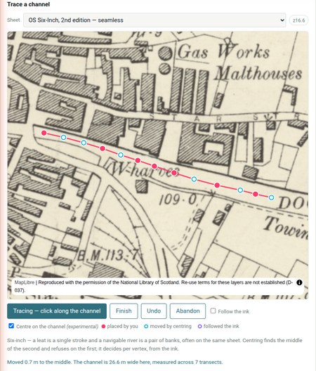
Both operations belong on the six-inch, then, chosen per reach rather than per sheet: Ordnance Survey draws a channel as one line below a certain ground width and as two banks above it, so a single sheet carries both — a leat as one stroke, a navigable river as a pair of banks. A tool that decided between them by which sheet was loaded would be wrong on every wide river.
Two reasons the six-inch is the surface, and neither is about resolution. The work queue is a transcription of the six-inch’s own labels, so every task points at something lettered on those sheets — send a contributor to a different survey and they are hunting for a caption that is not there. And the six-inch is served seamlessly across England and Wales where the 25-inch is county by county, so a national queue meets a national sheet. Finer is the wrong axis; the sheet that carries the task is the right one.
The interface says as much where a contributor will read it: a leat is a single stroke and a navigable river is a pair of banks, often on the same sheet.
And here is the limit, which is not a bug to be tuned away. Two roughly parallel lines a constant distance apart are a channel — and are also a lane, a gap between terraces, a railway. No test of the local pixels separates them. Asked for the strongest such feature anywhere in Ware, the assist returns a railway — and is correct about the geometry in every particular. What supplies the missing knowledge is the contributor, who knows they are following a watercourse. Nothing in the raster does.
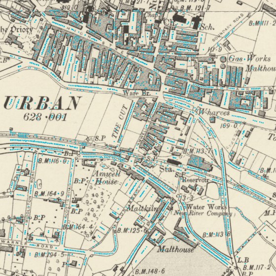
It is an assistant, not an interpreter, and the interface says so rather than leaving it to be inferred. Three consequences follow, and they are design rules and not caveats:
- Snapping is a separate switch from tracing. Ink runs out, forks, and is crossed by roads. Where it does, the only honest line is one a person draws, and the tool must let them draw it without pretending otherwise.
- Blank paper is never snapped to. Outside coverage, or where a tile is refused, a uniform field produces a confident-looking line and a false account of how it was made. The tool refuses rather than obliges.
- Which vertices were placed by hand and which by the algorithm is visible while tracing, not only recorded in the file. A machine-placed vertex looks more authoritative than a drawn one and is not — it is a reading of ink a person pointed at. The person most likely to over-trust it is the contributor, in the moment, and a provenance field only a later reader sees does nothing for them. This one is built: a hand’s vertex, a moved one and a followed one each draw differently, and a machine-laid run is drawn to look like less of a judgement than a placed point, because that is what it is.
What happens between the clicks
A channel bends, and two clicks are two points. Whatever the tool draws between them is an assertion nobody made — a straight segment says the channel runs straight from one to the other, which round a meander is simply false. So the question was never whether to infer something between the clicks, but which inference is least wrong, and how a reader is told which one was used.
The first answer did not work, and it is on this page for that reason. A curve that guessed the bend from the neighbouring clicks measured between three per cent worse and seven per cent better than plain straight segments on two genuinely sinuous reaches — which is to say it did nothing, and saved nobody a click. What was missing was information rather than smoothing: a guess made from points a meander’s width apart carries nothing about the bend between them. So the tool now lets a contributor state the direction the water leaves a point instead of inferring it, and that does measurably better. It is deliberately not a precision instrument — pointing roughly the right way is enough, and an interface that demanded more would put the tool out of reach of the people it exists for. It cannot rescue clicking too sparsely, and that limit was predicted before the gesture was built rather than discovered afterwards as a disappointment.
A curve somebody shaped and a curve the tool guessed are kept apart in the record, along with the clicks and the drags as they were made. A point on the first derives from something a person stated while looking at the sheet; a point on the second from an assumption nobody checked. They are different evidence, they are drawn differently, and a later reader can rebuild the line rather than having to trust it.
Whether any of this helps two people agree is unmeasured, and that is the claim the whole volunteer strand rests on. A drag is a new thing for two contributors to disagree about. Every distance above is between the tool and the ink; the distance that matters is between one person and another.
What the gate is, and what it is not
Access to the tool is controlled: invited contributors, and their traces recorded to this project under their own names — which is the point, since contributed work appears under its contributor’s name, and is also a disclosure. A contribution records a GitHub username, and that record is visible to everyone with access to this repository. It is said at sign-in rather than discovered afterwards, because consent is the remedy and concealment would not be one.
How a contributor is admitted is not settled, and this page will say what it actually asks of them when it is — including the cost, if there is one. It should not be read as sign in with an account you already have until it says so.
It does not restrict access to the maps. The historic sheets are served by the National Library of Scotland and anyone at all can fetch them, without a key and without asking us. The gate governs who uses this tool and where the traces go — nothing more. A page implying that the gate protects the sheets would be false, and it is the easiest false thing to imply by accident on a page about a tool that shows them.
The terms on which those sheets are served could not be traced, and what this project does about that is recorded rather than assumed.
What a trace carries
Every contributed line records the sheet it was read from, which vertices a hand placed and which the algorithm did, who drew it, and when. That is partly so a reader can weigh it — and partly because this project’s reading of what a traced line is is a ruling rather than a settled question, and those fields are what would let a source-restricted version of the dataset be extracted later without re-tracing anything.
Contributions reach the dataset as curated files in the repository’s existing idiom — diffable, each with a reason in words and its evidence — and under the ordinary rule: nothing is deleted to correct it. A trace supersedes; the line it replaces stays in the record, marked as superseded, because a reader has to be able to tell a correction from an omission.
| The scale of the work | why the tool exists, and how much there is |
| Evidence | what the sheets can say, and on what terms |
| Temporality | how a date is recorded, and why nobody types one |